So this entire trip is predicated on being in extremely good physical condition. If you can't hike all day at a forced-march pace with 40 plus lbs. of gear on your back for a minimum of 10 miles, then this trip is NOT for you.
Additionally you will be in one of the most beautiful places in the Western hemisphere - so bring a camera.
DAY ONE
You arrive mid afternoon at Norman Manley airport in Kingston Jamaica. If this were my trip, we would have embarked from Orlando Florida and the price of a round trip ticket would be approximately $400.00 per person.
Ground transportation in the form of a chartered mini-bus would take you on the one hour drive from the airport to your first stop at the little town Mavis Bank high in the Blue Mountains. I haven't shopped this specifically, but I believe the cost to be about $150.00 for the group.
Here you would be met by the driver from Whitfield Hall and you would change vehicles into a land rover for the very rugged trip. This drive is one of the steepest and most hair-raising trips you could ever imagine! I know cause I've been there. My trip, at night, up what seemed like a straight up incline, was in a land rover that had no less than 6 people inside, and another 6 or 8 people hanging onto the outside. I deeply regret that I don't have a picture, cause the image of it will remain in my mind forever. The cost of the land rover shuttle to Whitfield is $50 for 1 - 6 people.
Whitfield Hall is an old coffee plantation that provides guides and a staging point for the climb to the peak of Blue Mountain.

There is an old bunkhouse with bunk beds that's amply suited for resting up before the hike begins. No doubt dinner at Whitfield will be the plan and you can expect to spend about $10 bucks a head for some down home Jamaican cooking. Maybe some advance arrangements could be made and the menu would entail Oxtail and rice or curried goat.
DAY TWO
You arise to begin the hike between 1am and 2am the following morning. With flashlights in hand, and all the gear you'll need for the next 12 to 15 hours, you start your trek amid howling winds and under starry skies. Since there is no water at the peak, and one solitary tap about two thirds of the way up, you'll need to take a sufficient store of H2O. Warm clothes and some energy bars or light rations wouldn't be a bad idea either. At the 7,400 foot summit, the dampness (from being in the clouds much of the time) and the high winds and low temperatures will turn your well-earned sweatiness into misery. So some dry long johns and sweatshirt would be well worth the cost in weight carried.
The trail is initially very steep. I recall some hands and knees action at some points along the way. But mostly it's about the steepness of a standard staircase....just without the stairs. In short order upon starting out you'll be in a position to look back and see the lights of Kingston spread out below you. It's like one huge sheet of yellow light filling the Ligeaneau Plain.
Here's a couple of shots taken from about 1,500 to 3,000 feet above the city. You can maybe imagine the same view from 5,000 feet!

And here is an example of what the trail looks like:
Now the whole reason for beginning the climb in the wee hours of the morning is to enable you to reach the peak in time for sunrise. If the weather is clear you will be rewarded with a simultaneous view of both coasts of Jamaica, and a view of Cuba 90 miles away. If the weather is NOT clear, you'll see something like this:
Here are some miscellaneous views from high up on Blue Mountain:


Naturally, the trip down is a lot less difficult than the trip up, and being done in daylight the views are spectacular!
The next phase of the trip, once we're back to Mavis Bank, is to make the trip to Portland parish, presumably in a chartered bus. Again, I have not directly shopped this but I can safely bet that the cost for the two and half hour trip will be approximately $200.00 for the group.
Depending on the time it takes to descend from Blue Mtn. peak, we will arrive at our next stop, Frenchman's Cove, sometime late in the afternoon. The trip across the island will likely include the twenty-five miles of the Junction Road.
Now the Junction Road is winding and narrow with plenty of hairpin curves, cliffs, and sheer rock faces. Just your typical mountain highway in Jamaica really!
The evening of the second day, and a good place to rest up for the main event, is the old resort at Frenchman's Cove. Its beach is still one of the most gorgeous in all the Carribbean.
Once upon a time this place was top of the line. But it's run down quite a bit over the years. It's still a good place to rest up for the night, and depending of your budget you can get either a room or a cottage with a view of the ocean. For a 3 BR villa it's $300 a night - split by however many are in your party.
Here's one of the cottages I've stayed at before...
...and the view from its balcony.
We'll have to "forage" the area for food, and the price will be what the locals pay. I'll estimate the cost of eats to remain around $10 per head for Jamaican dishes.
Here are some views of the grounds at Frenchman's. Not too bad huh?

DAY THREE
Additional transportation from Frenchman's to Mooretown will be required, as well as breakfast along the way. Not sure the cost, but the trip is a fairly short one so $50.00 is a reasonable estimate.
In Mooretown we'll meet a guide who'll take us up the backside of the Blue Mountain to the site of the abandoned Maroon village called Nanny Town. There's a lot of history relating to the Maroons and the Nanny Town site. So rather than try to relate it all here, I suggest you just follow the links.
Rumor has it that the site of Nanny Town is haunted. Not unreasonable to expect that since most of the defenders leapt to their death off a 600 foot cliff, rather than surrender to the British in 1734. Apparently the legend has gained traction among the locals because several of the guides that bill themselves for this hike have one thing they have in common: they ALL refuse to camp overnight directly on the site.
It's a two day hike and you'll camp on the ground somewhere in the vicinity of the old village, but unless you defy the advice of your guide, you WON'T be camping right at Nanny Town. Hmmmm... methinks we'll see if this is true or not.
Nanny...the old Obeah priestess that led the Windward Maroons during the years of fighting the British.
I have not been on this hike personally so I have to rely on the reports of others, but Carribbean Hiking Guide says that it's even more difficult than the hike up Blue Mountain. Considering the British spent three years in their attempt to destroy it, Nanny Town's main asset must have been its remoteness and its general inaccessibility.
I am currently in negotiations for the correct guide service, and the exact price is presently unknown. But if the guide service on Blue Mtn. is any indicator, the bill will be on the order of $300.00 for the entire group.
DAYS FOUR AND FIVE
The return from Nanny Town will consume the majority of the day no doubt. We'll take another bus ride back to Frenchman's, and spend the next two days resting our feet, and enjoying the beer, the beach, the jerk pork and the fresh fish!
With many of the costs split over a group of five, I believe this trip is entirely possible for less than $1,500 per person. If we planned this trip a year in advance, I think most of us could manage it financially.
So? YARRRRRRRR ! Are ye willing to give it a go mates? Be ye men? Or be ye pansies?
Afterthought: If the two day hike to Nanny Town is too daunting, we could consider The Troy-Windsor trail through the Cockpit Country. Although this is only a one day trip, the terrain makes this a monster hike in its own right. Read this link thoroughly to get a feel for what I'm talking about.
The Cockpits look like this from the air: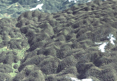
No big deal you think? Okay...here's what that type of Karst topography looks like when it is not covered by tropical jungles:
NOW you understand why, even in this age of satellite photography and GPS navigation, the Cockpit Country of Jamaica remains almost completely unexplored!


![[Most Recent Quotes from www.kitco.com]](http://www.kitconet.com/charts/metals/gold/t24_au_en_usoz_2.gif)









No comments:
Post a Comment